
Search Etsy for a 3D printed national park map and you will find plenty, mostly between $40 and $150, many of them beautiful. You will also find that the park you actually care about — the one where you got engaged, or finished the thru-hike, or scattered somebody's ashes — is usually not among them. Sellers stock the famous dozen.
The data behind all of them is public. A park is just a rectangle of ground, and the ground has already been surveyed. Here is how to make the one you want.
Frame the feature, not the boundary
The instinct is to match the park's legal boundary. It is almost always the wrong call.
Yosemite National Park is about 3,000 km². Fit all of it on a 150 mm plate and El Capitan — a 900 m wall that people spend days climbing — becomes a bump under two millimetres tall. The boundary is an administrative fact. It is not a composition.
Frame the thing people picture when they hear the name:
| Park | Frame this, not the park | Width |
|---|---|---|
| Yosemite | The Valley: El Capitan to Half Dome | 12–15 km |
| Grand Canyon | A stretch of gorge, not the whole 450 km | 25–30 km |
| Zion | Zion Canyon and the Narrows | 10–12 km |
| Rocky Mountain | Longs Peak and its cirque | 12 km |
| Acadia | Cadillac Mountain and the shoreline | 15 km |
| Great Smoky Mountains | Clingmans Dome ridge | 20 km |
A tight frame is not a compromise. It is the difference between a souvenir and an object somebody looks at twice.
Yosemite Valley, 14 km
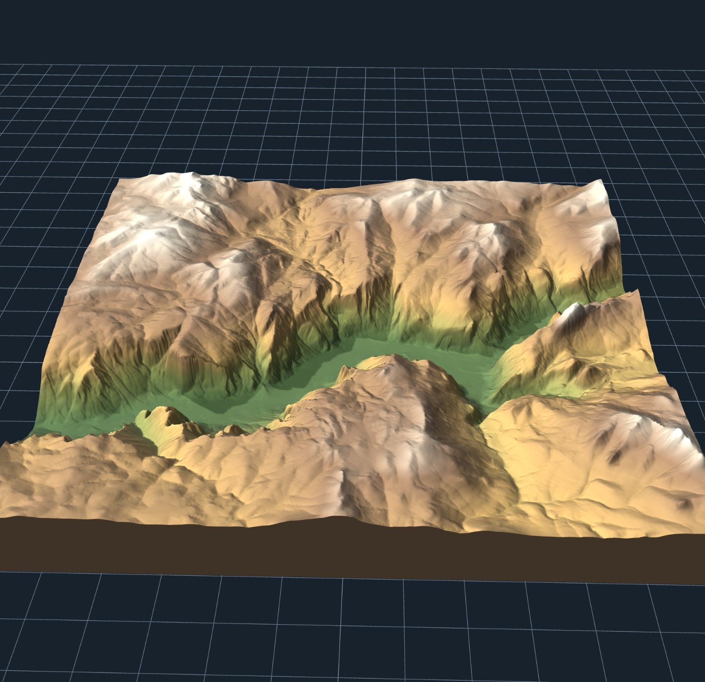
Note what the frame does. The valley floor reads as genuinely flat, the walls as genuinely vertical, and the contrast between them is the point. Widen to the park boundary and that contrast disappears into general lumpiness.
Exaggeration: less than you think, except when more
Parks split cleanly into two kinds, and they want opposite treatment.
Vertical parks — Yosemite, Zion, Rocky Mountain, Grand Teton — have enough range that 1× or 1.5× is plenty. Push these and the walls go past vertical, which prints badly and looks wrong to anyone who has stood at the bottom of one.
Broad parks — Everglades, Badlands at a wide frame, Great Smoky Mountains across the whole ridge — need help. 3× to 6×. The Everglades has under 3 m of range across its entire extent, so it is the rare case where honest terrain is simply not printable and you are making a land-cover map instead.
The sum, if you want it: relief in mm = (range ÷ width) × print width × exaggeration.
The Grand Canyon is a top-down subject
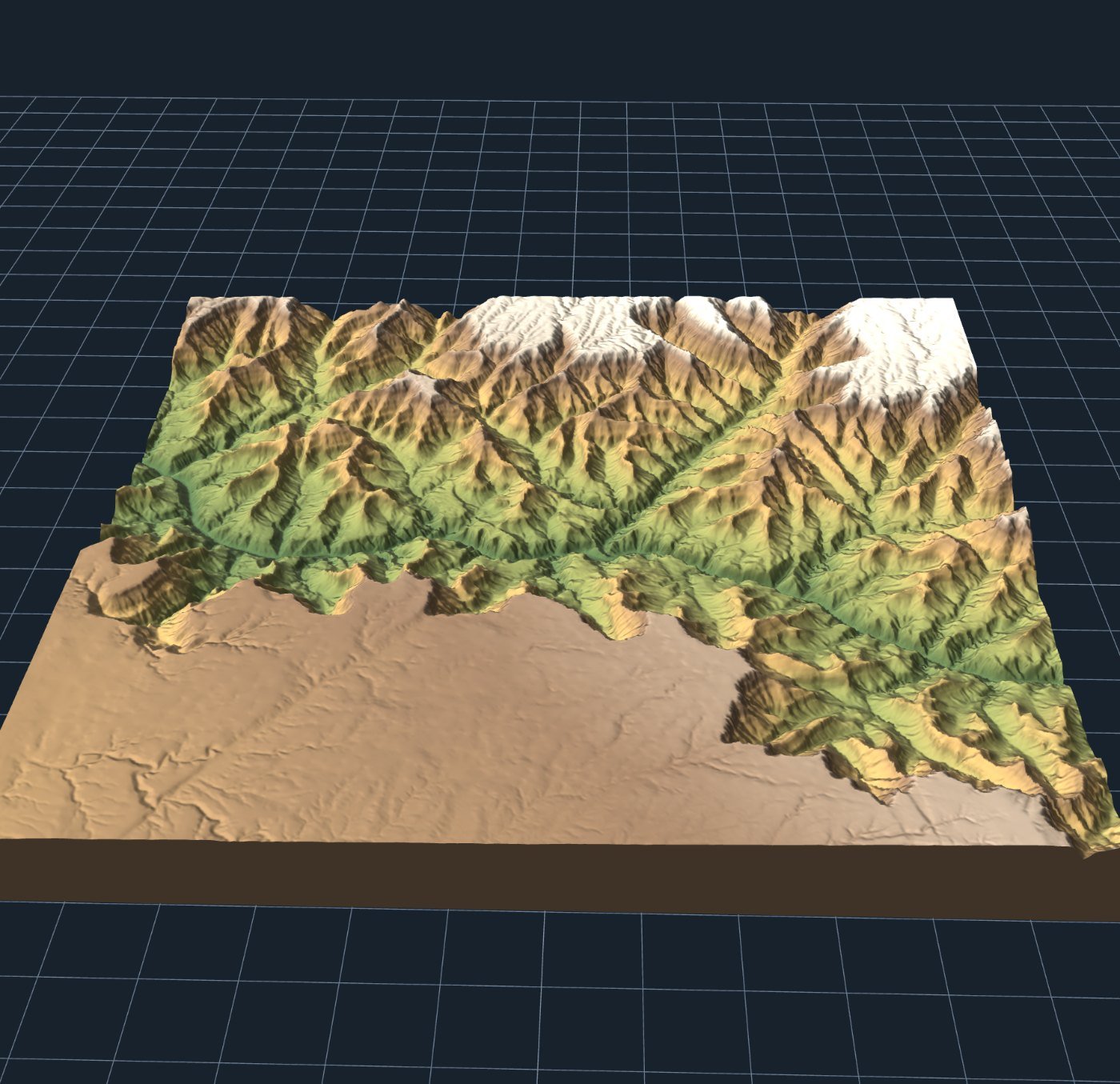
This is a general lesson about canyon country. Cut features read from above and disappear from the side, which is the opposite of peaks. If your subject is a canyon, a gorge or a fjord, plan on it being looked at flat on a table rather than propped on a shelf.
What to put on the surface
Three choices that suit parks particularly well:
- Contour lines. The most park-like option, because it is what the park's own trail maps look like. 100 m intervals for a mountain park, 20–50 m for a gentler one.
- Land cover. Woodland, rock, water and ice as separate colours. This is what makes Acadia or the Smokies work, where the story is forest meeting water rather than raw elevation.
- Inlaid water. Rivers and lakes cut into the surface rather than sitting on top. Essential for anywhere a river made the landscape — which, in canyon parks, is all of them.
What to leave off: roads and buildings. A park with its car parks extruded looks like a planning application.
Printing
Nothing unusual. Terrain is a heightfield, so there are no overhangs and no supports, however vertical Half Dome looks. 0.16 mm layers, three perimeters, 12% infill, a 4 mm base and a brim over 150 mm wide. Slow the top solid infill to 30–40 mm/s, because on a terrain model that surface is essentially the entire object.
Matte PLA, not glossy. A matte grey or bone-white park model photographs like something from a visitor centre; the same model in glossy filament looks like a toy.
For a gift, emboss the name and coordinates along the front edge of the base. "YOSEMITE VALLEY · 37.74°N 119.59°W" turns a nice object into one with a caption.
A note on selling them
If you are thinking about the Etsy listings: the elevation data is open and the map data is OpenStreetMap under ODbL, which has attribution requirements and terms about derived databases. Printing for yourself or as a gift, none of this matters. Selling prints, read the licences and credit OpenStreetMap in the listing — it is one line and it is the entire ask.
Park names and logos are a separate matter from the terrain data, and the US National Park Service has its own rules about its marks. The shape of the ground is not anybody's trademark; the arrowhead logo is.
Making one
Open the map maker framed on Yosemite Valley, or paste your own coordinates into the address bar. Switch on contour lines under Layers, set the print width, and export STL or 3MF.
The coordinates for any park are a search away, and the tool takes them directly. The one nobody sells is the one worth making.